To: Northern Arizona Proposed Withdrawal Project
ATTN: Scott Florence
Bureau of Land Managment
From: Nancy Freeman
Groundwater Awareness League, Inc.
P. O. Box 934
Green Valley, AZ 85622
Date: April 4, 2011
To assist in viewing tables this report can be viewed on website link:
www.mining-law-reform.info/GrandCanyon.htm
Dear Friends,
First, I want to commend you on the fine job you have done in collecting data and information to support a proposal to withdraw the Grand Canyon region from uranium mining in its entirely as laid out in Proposal B. My comments cannot begin to measure to the copious work you have done. However, I live in an area where uranium was mined and yellow cake was processed for approximately 20 years, from 1964 to 1983, at the Anaconda Twin Buttes facility in Sahuarita, Arizona.
At the present time, radionuclides are in the groundwater and seeping toward our public water supplies in Sahuarita and Green Valley. In fact, they are present at the mid-way point between the mine property and the town. Further, there are also numerous toxic chemicals in the soil and groundwater on the mine premises. The levels were deemed high enough that in 2008, EPA was considering it for the CERCLA list. However, the mining company wanted to complete a Voluntary Program, under the oversight of ADEQ, so that clean-up and data collection is in progress.
So in major part, I am furnishing you real-time, down-to-earth facts and figures that I have collected over the past eight years in an effort to obtain clean water in my community. Further, I would hope that no one will have to spend eight years of their life taking on a challenge to have clean water to drink.
General Environment
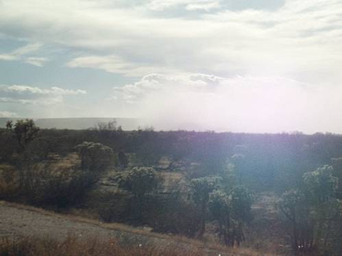
So most of my comments will be regarding the local situation, but, first, with the “a picture is worth a thousand words” framework, let’s take a look at the reality of what is being considered for our public lands in a region of recreation and wildlife:
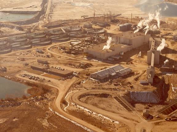
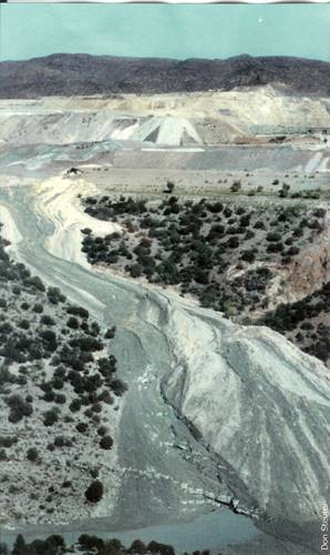
Ambrosia Lake Mill, New Mexico
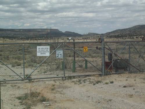
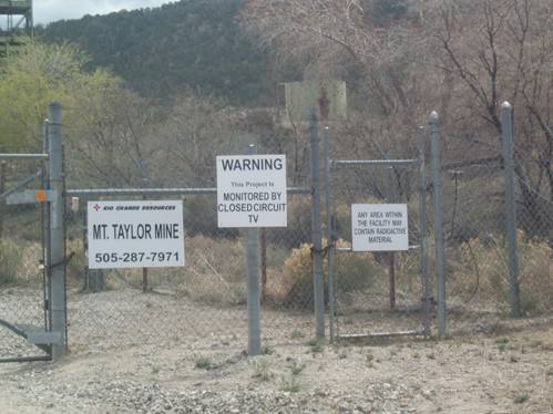
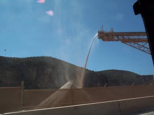
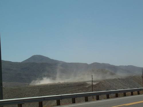
Since the Grand Canyon is a special place designated for human recreation and wildlife habitat, it needs to maintain a healthy environment to be accessible to the public. The citizens of the United States are the owner of the property. BLM and the Forest Service provide stewardship of those lands for the public. Therefore, the dividing up and fencing of the property would be contrary to the goals of the public trust. All mining, including uranium mining, requires fences, barriers and toxic chemical warnings. I do not feel that these barriers are appropriate for special public places, such as the Grand Canyon. The following two examples are from the Mt. Taylor uranium mine near Grants, New Mexico.
Environmental Contamination
The U. S. Environmental Agency (EPA) has published a recent (2008) report that uranium mining renders the region unfit for human—and therefore wildlife—use, even for recreational use.
Most abandoned uranium mines are likely to have elevated radium and uranium concentrations, and possibly elevated levels of other contaminants such as arsenic. An analysis of the location of uranium mine records indicates that many are on federal lands, so a primary exposure scenario pertains to short-term recreational activities, including short-term occupation.
Source: Technical Report on Technologically Enhanced Naturally Occurring Radioactive Materials from Uranium Mining, Volume 2: Investigation of Potential Health, Geographic, And Environmental Issues of Abandoned Uranium Mines
U.S. Environmental Protection Agency; Office of Radiation and Indoor Air
Radiation Protection Division (6608J)
1200 Pennsylvania Avenue; Washington , DC 20460
202-564-4355
www.epa.gov/radiation/docs/tenorm/402-r-08-005-volii/402-r-08-005-v2.pdf
Page 7-1
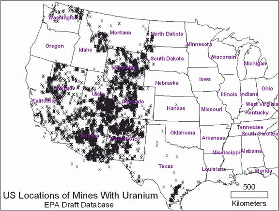
This entire report contains data of the contamination of the environment, including water, and the health risks caused by uranium mining. The information it contains should be given priority when considering where to place a uranium mine. As shown in the following map furnished by EPA, there are many sites for uranium, so it is not necessary to destroy a special place for the sake of uranium.
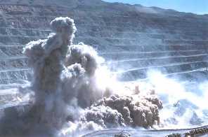
Specific contaminants: Dust
As is well known, dust has been an issue at the Grand Canyon, causing limited visibility. To allay the effects, the Navajo Generating plant was required to install more efficient burners at a cost of $47 million and catalectic reduction units are now being installed at a cost of $400 million.
Dust from mining operations is an on-going concern for the health of the environment. The principal cause of dust complaints is dust from the tailings impoundments. In the mining region where I live, dust from the impoundments is a continual problem. Scott Porter, Pima County DEQ, stated in a recent public meeting that the department receives approximately 50 complaints a year, usually when the wind reaches 25 mph.
ASARCO Mission Mine Impoundment, Sahuarita , AZ
Source: Scott Porter
Air Quality Compliance Division
Pima County Department of Environmental Quality
Tucson, Arizona
520/243-7383
In comparing the wind rates in Grand Canyon and Tucson International Airport, it is noted that they are very similar. Therefore, it could be surmised that there would be a similar scenario on any mining site at the Grand Canyon.
Climate Historical Summaries
http://www.wrcc.dri.edu/Climsum.html
________________________________________
Climatological Data Summaries (LCD)
(Temperature, Sunshine, Sky Cover, Station Pressure, Humidity, Precipitation and Wind.)
Summaries based on unedited daily ASOS data.
Grand Canyon Wind:
WIND-MPH-Avg. | Jan Feb Mar Apr May Jun Jul Aug Sep Oct Nov Dec | Year 1996-2008
|
Daily Avg Wind Speed| 6.0 6.5 6.5 7.9 7.3 7.4 5.2 4.7 5.7 5.9 5.5 5.8 | 6.2
Daily Avg Max 2-Min 16.8 18.4 19.5 22.7 22.3 22.9 19.7 18.6 19.6 18.4 17.3 16.7 | 19.4
Daily Avg Peak Gust | 21.3 23.7 25.4 29.7 29.6 30.7 26.2 24.4 25.9 24.2 22.0 21.6 | 25.4
| |
Maximum Daily Avg | 19.4 21.5 19.6 22.2 23.4 19.1 12.5 12.2 19.6 21.8 18.5 23.5 | 23.5
Max. 2-Minute Avg | 44 46 41 45 41 44 35 33 37 46 40 44 | 46
http://www.wrcc.dri.edu/summary/gcn.az.html
Tucson Airport Wind:
WIND-MPH-Avg. | Jan Feb Mar Apr May Jun Jul Aug Sep Oct Nov Dec | Year 1996-2008
| |
Daily Avg Wind Speed| 6.6 7.0 7.5 8.0 7.8 7.8 7.4 7.0 7.3 7.3 6.8 6.5 | 7.3
Daily Avg Max 2-Min |16.6 17.4 18.5 19.8 19.3 20.3 22.4 21.2 18.9 17.9 16.6 17.0 | 18.8
Daily Avg Peak Gust | 21.4 22.4 23.8 25.7 25.1 26.5 28.3 27.1 24.1 23.2 21.6 21.9 | 24.3
| |
Maximum Daily Avg | 22.5 18.5 20.9 17.2 17.4 15.5 13.4 22.4 17.3 22.9 20.2 19.1 | 22.9
| |
Max. 2-Minute Avg| 36 37 40 39 35 48 55 48 44 38 35 36 | 55
http://www.wrcc.dri.edu/summary/tus.az.html
There are other sources of dust, particularly the crushing areas, dirt roads, that would also be augmented by wind speed.
Crushing operations, Morenci , AZ
Road dust at ASARCO Ray Mine, AZ
It is important to recognize that the Arizona Department of Environmental Quality is a regulatory agency that accesses fines for non-compliance to the air quality permits. The permits effectively set levels that the company is allowed to pollute. ADEQ can not and does not stop air quality problems. Do we want more dust in the Grand Canyon region? More importantly, do we want dust that is laced with uranium and its components in the Grand Canyon region?
Water
The major contaminant in this mining region has been the water. Even though uranium was mined in this region, there is no requirements from EPA or ADEQ that water monitoring near the mines or in the impoundments for uranium and its components. The very little data available, I obtained from the local mining company, but they were very clear: “we do not have to test for uranium and radioactive components.”
The following link gives tables for the few monitor wells that were tested:
www.savethesantacruzaquifer.info/Radionuclides.htm
At the two monitor wells near the mill area, the levels of gross alpha averaged from 50 to 150 pc/l and from 600 to 1,000 in the second one. The levels in the wells off site are within the allowable rates, but they are moving toward Green Valley and Sahuarita.
Monitor Well No. BW-3
On-site: South of milling area near Duval Canal
Date |
Gross Alpha pc/l |
Gross Beta pc/l |
Radium 226 pc/l |
Radium 228 pc/l |
Radon* 222 pc/l |
Uranium 234 pc/l |
Uranium 235 pc/l |
Uranium 238 pc/l |
Total Uranium mg/l |
|||||
2/27/98 |
134 ± 13 |
56 ± 25 |
0.9 ± 0.6 |
3.1 ± 1.2 |
0.14 |
|||||||||
6/19/98 |
109 ± 7 |
23 ± 25 |
0.14 |
|||||||||||
9/24/98 |
97 ± 10 |
25 ± 24 |
1.6 ± .36 |
3.7 ± 0.7 |
0.14 |
|||||||||
12/7/98 |
87 ± 8 |
48 ± 24 |
0.14 |
|||||||||||
3/10/99 |
70 ± 21 |
56 ± 13 |
0.14 |
|||||||||||
6/14/99 |
40 ± 20 |
7.4 ± 13 |
0.0569 |
|||||||||||
4/5/00 |
110 ± 34 |
50 ± 18 |
0.131 |
|||||||||||
7/3/00 |
140 ± 35 |
49 ± 18 |
0.123 |
|||||||||||
11/8/00 |
44 ± 20 |
16 ± 13 |
0.0398 |
|||||||||||
7/11/01 |
21.2 ± 15 |
49.2 ± 18 |
0.143 |
|||||||||||
10/16/01 |
80.1 ± 23 |
42.7 ± 16 |
31.1 ± 2.1 |
1.29 ± .87 |
24.6 ± 2.1 |
0.116 |
||||||||
2/14/02 |
34.6 ± 18 |
34.6 ± 12 |
36.2 ± 3.9 |
0.86 ± 0.96 |
39 ± 4.1 |
0.132 |
||||||||
4/10/02 |
25.5 ± 16 |
26.9 ± 13 |
1.78 ± 0.3 |
2.82 ± 0.8 |
12.1 ± 2.3 |
1.75 ± 1.1 |
12.1 ± 2.4 |
0.0898 |
||||||
9/10/02 |
36.8 |
42.1 |
23.4 |
0.39 |
27.3 |
0.0799 |
||||||||
11/13/02 |
<6.68 |
52.2 |
<1.78 |
0.1 |
1.18 |
<0.0003 |
||||||||
1/22/03 |
61 |
52.2 |
43.2 |
1.13 |
44.2 |
0.174 |
||||||||
4/15/03 |
24.9 |
29.9 |
23.7 |
0.45 |
25.2 |
0.0735 |
||||||||
8/11/03 |
69.9 ± 3.8 |
51.5 ± 4.0 |
2.2 ± 0.5 |
ND |
4,280 ±101 |
22.4 ± 2.4 |
1.3 ± 0.6 |
22.3 ± 1.5 |
0.0878 |
|||||
11/12/03 |
98.6 ± 4.5 |
33.9 ±12.5 |
2.3 ± 0.7 |
ND |
15,600±140 |
36.9 ± 3.0 |
1.6 ± 0.6 |
35.6 ± 2.9 |
0.145 |
|||||
3/22/04 |
20.2 ± 5.3 |
24.1 ± 2.0 |
1.4 ± 0.4 |
1.7 ± 1.0 |
5,140± 95.5 |
7.9 ± 1.4 |
0.2 ± 0.2 |
8.9 ± 1.4 |
0.0306 |
|||||
MCLG** |
0 |
0 |
Ra-226+ -228 = 0 |
None |
None |
None |
None |
0 |
||||||
MCL*** |
15 pCi/l |
4 mrem/yr |
Ra-226+ -228 = 5 |
None |
None |
None |
None |
0.03 mg/l |
||||||
* Radon has no standard.
** Maximum Contaminant Level Goal, 40 C.F.R. § 141.55.
***Maximum Contaminant Levels, 40 C.F.R. § 141.66(b) [for Ra-226+-228]; (c) [for gross alpha activity]; (d) [for beta particle and [photon radioactivity]; and (e) [for uranium].
Monitor Well No. MH-21
Monitor well northeast of Phelps Dodge Sierrita mill area at Demetrie Wash
Date |
Gross Alpha pc/l |
Gross Beta pc/l |
Radium 226 pc/l |
Radium 228 pc/l |
Radon* 222 pc/l |
Uranium 234 pc/l |
Uranium 235 pc/l |
Uranium 238 pc/l |
Total Uranium mg/l |
||||||
6/27/97 |
557 ± 64 |
334 ± 44 |
7.3 ± 0.9 |
9.1 ± 1.5 |
1.1 |
||||||||||
8/19/97 |
406 ± 54 |
299 ± 40 |
15 ± 2 |
6.2 ± 1.5 |
0.73 |
||||||||||
3/17/98 |
1,000 ± 30 |
375 ± 40 |
13 ± 2 |
8.3 ± 1.5 |
156 ± 5.13 |
20.0 ± 1.88 |
202 ± 5.85 |
0.56 |
|||||||
6/17/98 |
1,190 ± 20 |
264 ± 40 |
1.6 |
||||||||||||
9/23/98 |
955 ± 29 |
272 ± 39 |
10 ± 0.798 |
7.3 ± 7.3 |
1.5 |
||||||||||
12/02/98 |
662 ± 31 |
312 ± 38 |
1 |
||||||||||||
3/08/98 |
654 ± 63 |
207 ± 21 |
|||||||||||||
9/30/99 |
1,000 ± 99 |
150 ± 20 |
1.27 |
||||||||||||
1/06/00 |
880 ± 84 |
400 ± 33 |
1.51 |
||||||||||||
4/5/00 |
690 ± 74 |
210 ± 27 |
1.34 |
||||||||||||
10/30/00 |
750 ± 13 |
240 ± 19 |
1.19 |
||||||||||||
1/10/01 |
1,000 ± 92 |
360 ± 30 |
1.44 |
||||||||||||
4/05/01 |
760 ± 76 |
280 ± 29 |
340 ± 16 |
12 |
350 ± 17 |
1.31 |
|||||||||
7/16/01 |
1090 ± 94 |
386 ± 34 |
1.48 |
||||||||||||
10/18/01 |
895 ± 74 |
345 ± 26 |
1.32 |
||||||||||||
2/15/02 |
853 ± 75 |
221 ± 22 |
345 ± 11 |
13.2 ± 3.9 |
374 ± 12 |
1.15 |
|||||||||
4/11/02 |
665 ± 68 |
325 ± 27 |
14.1 ± 0.8 |
6.86 ± 1.0 |
362 ± 12 |
12 ± 2.4 |
367 ± 13 |
1.08 |
|||||||
9/11/02 |
503 |
288 |
286 |
11.2 ± 2.4 |
312 |
.901 |
|||||||||
11/13/02 |
447 |
399 |
376 |
11.8 |
387 |
1.1 |
|||||||||
1/23/03 |
504 |
367 |
357 |
14.3 |
387 |
1.37 |
|||||||||
4/17/03 |
562 |
330 |
358 |
17.2 |
386 |
1.14 |
|||||||||
8/12/03 |
716 ±9.2 |
382 ± 11.8 |
306 ± 8.4 |
7.6 ± 1.3 |
336 ± 8.8 |
1.26 |
|||||||||
11/19/03 |
701 ± 8.8 |
270 ± 12.2 |
304 ± 7.3 |
12.0 ± 1.4 |
320 ± 7.5 |
1.24 |
|||||||||
3/09/04 |
709 ± 29 |
214 ± 11.4 |
364 ± 8.8 |
14.7 ± 1.8 |
385 ± 9.0 |
1.19 |
|||||||||
MCLG** |
0 |
0 |
Ra-226+ 228 = 0 |
None |
None |
None |
None |
0 |
|||||||
MCL*** |
15 pCi/l |
4 mrem/yr |
Ra-226+ -228 = 5 |
None |
None |
None |
None |
0.03 mg/l |
|||||||
Monitor Well No. MH-15W
On east side of center of Phelps Dodge tailings pond
Date |
Gross Alpha pc/l |
Gross Beta pc/l |
Radium 226 pc/l |
Radium 228 pc/l |
Radon 222 pc/l |
Uranium 234 pc/l |
Uranium 235 pc/l |
Uranium 238 pc/l |
Total Uranium mg/l |
2/26/98 |
64 ± 9 |
18 ± 24 |
0.2 ± 0.4 |
0.2 ± 1.1 |
0.061 |
||||
6/22/98 |
60 ± 5 |
11 ± 24 |
0.069 |
||||||
9/28/98 |
68 ± 8 |
22 ± 25 |
.006 ± 0.1 |
0.065 |
|||||
12/04/98 |
72 ± 20 |
25 ± 26 |
0.061 |
||||||
3/09/99 |
53 ± 17 |
20 ± 11 |
0.0483 |
||||||
4/15/99 |
43 ± 9.8 |
25 ± 6 |
0.0243 |
||||||
6/10/99 |
29 ± 14 |
23 ± 11 |
0.0508 |
||||||
10/11/99 |
52 ± 25 |
8.6 ± 12 |
0.06 |
||||||
4/11/00 |
60 ± 20 |
16 ± 13 |
0.0535 |
||||||
7/5/00 |
66 ± 22 |
8.9 ± 12 |
0.0561 |
||||||
10/9/00 |
55 ± 18 |
99 ±12 |
0.72 |
||||||
4/02/01 |
130 ± 70 |
88 ± 61 |
0.0444 |
||||||
2/19/02 |
61.2 ± 20 |
24.8 ± 10 |
31.2 |
1.05 ± 0.96 |
20.8 ± 2.8 |
0.0532 |
|||
4/15/02 |
34 ± 15 |
25.2 ± 13 |
0.17 ± 0.2 |
0.76 ± 0.7 |
28.1 ± 3.4 |
1.58 ± 1.1 |
17.3 ± 2.8 |
0.0541 |
|
9/13/02 |
51.6 |
27.9 |
24.3 |
0.32 |
17.4 |
0.0492 |
|||
11/14/02 |
25.7 |
35.4 |
23.9 |
0.26 |
18.1 |
0.0455 |
|||
1/24/03 |
20.2 |
18.2 |
23.3 |
1.25 |
16.1 |
0.0474 |
|||
4/22/03 |
73.5 |
50.1 |
27 |
0.6 |
21.5 |
0.0478 |
|||
8/11/03 |
54.5 ± 2.4 |
37.1 ± 2.7 |
ND |
ND |
671 ± 66.6 |
26.3 ± 2.3 |
1.0 ± 0.4 |
16.8 ± 1.8 |
0.0565 |
11/27/03 |
55.2 ± 2.6 |
55.3 ± 8.2 |
ND |
ND |
760 ± 68.0 |
24.8 ± 2.0 |
0.6 ± 0.3 |
17.7 ± 1.7 |
0.0708 |
3/11/04 |
55.3 ± 3.7 |
9.3 ± 7.6 |
ND |
ND |
780 ± 79.0 |
27.8 ± 2.6 |
0.6 ± 0.4 |
19.3 ± 2.2 |
0.0602 |
MCLG** |
0 |
0 |
Ra-226+ -228 = 0 |
None |
None |
None |
None |
0 |
MCL*** |
15 pCi/l |
4 mrem/yr |
Ra-226+ -228 = 5 |
None |
None |
None |
None |
0.03 mg/l |
Three monitor wells on public state land between Phelps Dodge Sierrita tailings dam and Green Valley , approximate ¾ mile from impoundment:
Monitor Well No. MH-11
|
|
|
|
|
|
|
|
|
|
8/14/03 |
5.2 ± 1.1 |
14.0 |
ND |
ND |
734 ± 79.4 |
4.0 ± 0.9 |
ND |
1.1 ± 0.5 |
0.0062 |
12/02/03 |
8.0 ± 1.3 |
24.5 ± 7.8 |
0.9 ± 0.4 |
ND |
673 ± 48.1 |
3.1 ± 0.9 |
ND |
2.1 ± 0.7 |
0.0067 |
3/16/04 |
5.8 ± 1.3 |
12.7 ± 7.0 |
ND |
ND |
618 ± 56.4 |
3.2 ± 0.7 |
ND |
2.1 ± 0.6 |
0.0059 |
Monitor Well No. MH-12
|
|
|
|
|
|
|
|
|
|
12/02/03 |
5.3 ± 1.6 |
19.7 ± 4.7 |
0.5 ± 0.4 |
ND |
535 ± 45.9 |
2.7 ± 0.9 |
0.2 ± 0.2 |
0.9 ± 0.5 |
0.0045 |
3/15/04 |
4.9 ± 1.8 |
24.4 ± 4.2 |
0.5 ± 0.3 |
ND |
2.9 ± 0.7 |
ND |
ND |
1.0 ± 0.4 |
0.0042 |
Monitor Well No. MH-13
|
|
|
|
|
|
|
|
|
|
8/14/03 |
10.8 ± 1.6 |
23.7 ± 2.6 |
ND |
ND |
ND |
6.4 ± 1.1 |
0.4 ± 0.3 |
2.4 ± 0.7 |
0.0099 |
12/02/03 |
13.0 ± 2.5 |
37.5 ± 7.8 |
0.5 ± 0.3 |
ND |
ND |
8.0 ± 1.2 |
0.3 ± 0.2 |
2.6 ± 0.7 |
0.0098 |
3/11/04 |
9.5 ± 3.1 |
13.3 ± 7.0 |
ND |
ND |
ND |
6.8 ± 1.2 |
ND |
2.8 ± 0.8 |
0.0082 |
MCLG** |
0 |
0 |
Ra-226+ 228 = 0 |
None |
None |
None |
None |
0 |
|
MCL*** |
15 pCi /l |
4 mrem /yr |
Ra-226+ -228 = 5 |
None |
None |
None |
None |
0.03 mg/l |
|
—There are other water considerations. The loal copper mining operation uses 30,000 acre feet of water in their operations per year. The water table is dropping a couple of feet per year. All trees except mesquite and palo verde have disappeared in this regionexcept ones that are being irrigated.
Other Considerations:
ANFO Explosions:
Tailing Dam Failures:
Haunted Canyon
Wildlife issues:
Note the company used noise-makers (ie. Rifles shot in the air) to frighten off the birds. I don't think that will work at the Grand Canyon!
Phelps Dodge pleads guilty to violating bird act
Associated Press
Aug. 31, 2005 07:20 AM
ALBUQUERQUE, N.M. - Phelps Dodge pleaded guilty Tuesday to a misdemeanor charge of violating the Migratory Bird Treaty Act after dozens of dead birds were found at one of the copper giant's operations in southwest New Mexico.
The U.S. attorney's office in Albuquerque said the Phoenix-based company agreed to pay a $15,000 fine and take corrective action to help stop the bird deaths at the Tyrone mine site as part of a plea agreement.
More than 70 birds were found dead at the site between September 2000 and December 2004, according to court documents. Since that time, more than 40 additional dead birds have been found.
The U.S. attorney's office said some of the impounded waters at the site contained acidic water from the mining process. Studies have shown that ingestion of sulfuric acid and copper solutions can be lethal to migratory birds.
As part of the plea agreement, Phelps Dodge will donate $15,000 to the Fish and Wildlife Foundation to be designated for avian habitat restoration or for migratory bird studies within the Gila River ecosystem.
Phelps Dodge also pleaded guilty to violating the bird act last August in Arizona after dozens of migratory birds died from drinking acidic water at the Morenci copper mine. As a preventative measure, the company spent more than $1 million to scare away birds with noisemakers and fake peregrine falcons.
Conclusion:
It should be relevant that the the Arizona constitution gives rights to the public for takings.
Arizona State Constitutional Rights
17. Eminent domain: just compensation for private property taken; public use as judicial question
Section 17. Private property shall not be taken for private use, except for private ways of necessity, and for drains, flumes, or ditches, on or across the lands of others for mining, agricultural, domestic, or sanitary purposes. No private property shall be taken or damaged for public or private use without just compensation having first been made, paid into court for the owner, secured by bond as may be fixed by the court, or paid into the state treasury for the owner on such terms and conditions as the legislature may provide, and no right of way shall be appropriated to the use of any corporation other than municipal, until full compensation therefore be first made in money, or ascertained and paid into court for the owner, irrespective of any benefit from any improvement proposed by such corporation, which compensation shall be ascertained by a jury, unless a jury be waived as in other civil cased in courts of record, in the manner prescribed by law. Whenever an attempt is made to take private property for a use alleged to be public, the question whether the contemplated use be really public shall be a judicial question, and determined as such without regard to any legislative assertion that the use is public.
So these are the many reasons we have to use caution and discretion in placing our minesespecially uranium mines. Thank You for choosing Alternative B to withdraw all acreage possible for public use instead of private profit.
Again, I want to commend the BLM for the fine job they are doing in being stewards of public lands. Other agencies use the excuse of the 1872 mining law to do nothing. Whereas, the public lands in Arizona were created after 1872, principally for watershed and public recreation. Therefore, these important uses post date and preempt any prior regulations. As we know the purpose of the Forest Service is to harvest trees, therefore, they consider that the trees that we have in Arizona have no value. [Recent Forest Service letter] In other words, if you don't protect the land, the water, the trees and the habitat for wildlife, no one will. Thank you.