To: Senators of Public Lands and Forests sub-committee
Submitted by: Nancy Freeman, Executive Director
Groundwater Awareness League, Inc.
P. O. Box 934
Green Valley , AZ 85622
520-398-4340
Date: June 29, 2009
Subject: Responses to hearing held June 16, 2009 on Southeast Arizona Land Exchange and Conservation Act of 2009; Senate Bill S.409
I feel there are points relevant to assessment of the proposed Resolution Copper land exchange. I am not against mining per se—but why not mine in areas that are already wastelands. There are plenty of wastelands in the southwest. Why create another one? Mining impacts the whole eco-system in ways that we cannot imagine. Mining needs to be done where there is plenty of water and no population of humans, animals or plants. The environment will be affected, and these affects should be accessed carefully before any mining is even considered.
Many environmental concerns need to be addressed. What happens to the 99% of the 110,000 tons of hard rock dug out of the underground pit? Where will they get the 30,000 acre feet of water annually? Where will they get the electricity? Senator Kyl stated that they did not know how they will get the ore out.
After all these years in Congress, Senator Kyl appears to be unaware that there are different environmental processes on public and private property. Mining operations on private lands fall under state laws, which are usually more lax, and certainly are in Arizona.
“Substantial benefits” is the theme song. Senators McCain and Kyl say America needs this copper. Jobs will be created. The question of royalty did come up in the hearing, which is a major theme in mining law reform; however, the wording in the bill doesn’t make sense, and does not specify a time or rate for any royalty.
The number of projected jobs changes regularly. Last year, the number was 500 mining jobs, last month it was 1,200 and at the hearing the number 1,400 jobs was mentioned. However, if the price of copper is about $3.50 per pound, the salaries will only be some 5% of the profits. Who will get the 95%?
Senators McCain and Kyl continue to admonish the detractors to think of the future and the need for copper. We are thinking of the future—what about 50 years from now when there are new mining techniques, a fair royalty for the public, or even mining co-ops that mine for the public benefit. At present, the only substantial benefactors will be the Rio Tinto and BHP stockholders.
Assessments and information on these points to address follows:
1) Environmental issue of deposition of waste rock, tailings and waste concentrate needs to be addressed
2) Source of water supply for mining operations needs to be addressed
3) Where is the electrical grid to provide power to hoist 110,000 tons of rock containing 1% copper from 5,000 to 7,000 feet daily?
4) Value of exchange properties needs to be analyzed and publicized
5) Method of calculation of royalty to public needs to be clarified
6) Destruction of Scenic Highway needs to be addressed
1) Environmental issue of deposition of waste rock, tailings and waste concentrate needs to be addressed
Resolution Copper plans to pull out 110,000 tons of rock a day. Where will they put this rock? This bulk would equal a 20 story building (200 ft) spread over 3,000 acres. The waste is divided into three categories: waste rock with no copper, slurry from flotation process, and waste from smelting process. These categories of waste comprise the biggest environmental problems. Rio Tinto has created such an underground plume from seepage of waste at Bingham Canyon, south of Salt Lake that it had to be divided into two parts to be handled by the Environmental Protection Agency.
www.epa.gov/region8/superfund/ut/kennecottnorth/index.html
www.epa.gov/region8/superfund/ut/kennecottsouth/
Further, BHP, along with Freeport-McMoran (formerly Cyprus) has had problems with its mining waste in the nearby Miami, creating an Arizona Superfund site at Pinal Creek.
www.g-a-l.info/Remedial Action.htm
There are some potential plans to pipe the tailings to a nearby mine site to be put into a pit on BHP property. Since slurry will seep into the groundwater table, Pinto Creek watershed could become involved. Therefore, Arizona Department of Environmental Quality and Environmental Protection Agency would be involved with water pollution in accordance with U.S. Ninth Circuit Court of Appeals ruling in November, 2007, prohibiting additional pollution in the region of Pinto Valley. [See Attachment One.] There are laws in Arizona regarding water, as Resolution Copper already found this out when they planned to dump billions of gallons of extremely toxic water into nearby Queen Creek. Arizona Dept. of Environmental Quality prevented this action. Further, the amount of waste may exceed the volume available in the pit.
Contact:
Arizona Department of Environmental Quality
1110 W. Washington
Phoenix , AZ 85007
602/771-2300
Justin Berns
Surface Water Section
JD17@azdeq.gov
2) Source of water supply for mining operations needs to be addressed
This issue was addressed adequately in the comments submitted by Groundwater Awareness League on. June 16, 2009. Available at www.mining-law-reform.info/RCCWater.htm
3) Where is the electrical grid to provide power to hoist 110,000 tons of rock containing 1% copper from 5,000 to 7,000 feet daily?
One area that is rarely considered is the fuel consumption of the mining industry. The mining of metals is one of the most energy intensive industries in the world, consuming up to 10 percent of global energy production annually. In the United States alone, the mining industry uses 2.3 quadrillion (2,300,000,000,000,000) BTUs of energy per year. That is enough energy to supply over 25 million single family households in the United States for an entire year. Again, energy production uses large amounts of water. Power lines and substations will surely create another scar across the landscape.
4) Value of exchange properties needs to be analyzed and publicized.
The values of over-grazed ranch lands, which Senator McCain jokingly referred to as “national treasures,” have been over-rated. Further, “old growth,” that is “original growth” in its usual meaning, mesquite forests do not exist. Traditionally, southwest Arizona was covered with grasslands. Ranchers came in during the late 1800’s and by the early 1900’s had destroyed the natural grasses. They also cut down trees along the river banks to plant alfalfa for their cattle. Mesquites only grew along dry washes. West Texans call mesquite the “weed from hell.” Blogs exist on the Internet with questions, such as “How does everyone else get rid of these cursed things?” They are an inevitable result of ranching as the cows eat the beans because they have destroyed the grasslands. Then the cows distribute the beans far and wide with a cow paddy to give them a fresh start.
(1) to the Secretary of Agriculture, all right, title, and interest that the Secretary determines to be acceptable in and to--
(A) the approximately 147 acres of land located in Gila County, Arizona, depicted on the map entitled `Southeast Arizona Land Exchange and Conservation Act of 2009-Non-Federal Parcel-Turkey Creek' and dated January 2009;
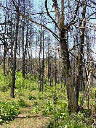
Three years ago the Pitcher Fire burned much of this 147-acre ranch including both its riparian hardwoods and the ranch’s adjacent ponderosa forest. With decades of overgrazing, one finds little unburned mature riparian vegetation here. The stream flow currently is intermittent (underground at times) with only a trickle on the surface, even after a record wet spring this year. The ranch's nearly impassible 4WD access road makes this property inaccessible to the general public.
(B) the approximately 148 acres of land located in Yavapai County Arizona, depicted on the map entitled `Southeast Arizona Land Exchange and Conservation Act of 2009-Non-Federal Parcel-Tangle Creek' and dated January 2009;
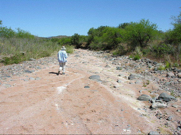
This ranch also has a bone-dry river bottom for the full one mile length of the ranch. It is devoid of sufficient water to support cottonwood, willow, sycamore or ash riparian vegetation even if it were over-grazed. Only three forlorn medium-to-small sycamores exist near the dry creek. There is one willow at a nearly dry, filthy, algae-filled stock pond near the abandoned homestead. Like the Cave Creek and Turkey Creek swap properties, this cattle-devastated parcel will continue to be grazed after it is traded to the Forest Service. The acquisition of this property is of little or no real benefit to the Tonto National Forest or the public at large.
(C) the approximately 149 acres of land located in Maricopa County, Arizona, depicted on the map entitled `Southeast Arizona Land Exchange and Conservation Act of 2009-Non-Federal Parcel-Cave Creek' and dated January 2009; [ie, 6L Ranch]
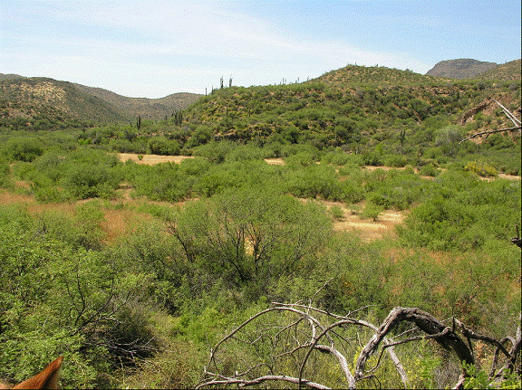
The property is limited in size, and heavily disturbed by past settlement and chronic overgrazing. The area’s rich archeological resources are protected by the defacto non-motorized access created by the Spur Cross Ranch Conservation Area to the South, and the forest lands that surround it on all sides. The existing resource values of the area will not change nor be enhanced as a result of a change in ownership. The acquisition of the 6L property is of little benefit to the Tonto National Forest or the public at large.
(D) the approximately 88 acres of land located in Pinal County, Arizona, depicted on the map entitled `Southeast Arizona Land Exchange and Conservation Act of 2009-Non-Federal Parcel-J-I Ranch' and dated January 2009;
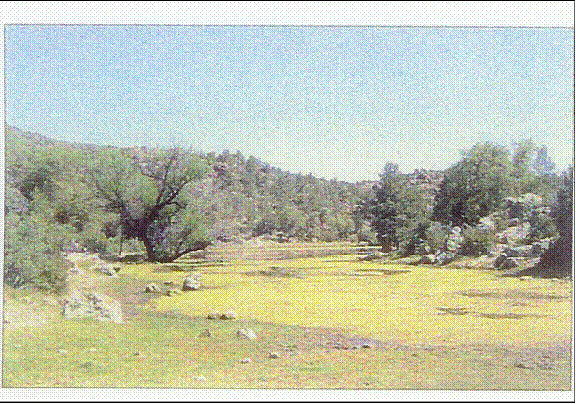
This ranch has hoof and cow dung impacted stock ponds and a brief half-mile ephemeral stream with mature sycamore and oak vegetation. One stock tank is described as "perennial" in Resolution Copper’s PR literature to Congress. They describe that pond as a site for a replacement campground for the Oak Flat Campground and that this "stock pond area would be highly desirable for dispersed camping opportunities." Resolution mis-describes that degraded stock pond and its one willow tree (the only riparian habitat tree species there) as "…habitat for a large array of birds…"
(E) the approximately 640 acres of land located in Coconino County, Arizona, depicted on the map entitled `Southeast Arizona Land Exchange and Conservation Act of 2009-Non-Federal Parcel-East Clear Creek' and dated January 2009;
There are some ideal locations on East Clear Creek, however, the information contained in the bill is not sufficient to check the exact location on the creek.
(2) to the Secretary of the Interior, all right, title, and interest that the Secretary of the Interior determines to be acceptable in and to—
(A) the approximately 3,073 acres of land located in Pinal County, Arizona, depicted on the map entitled `Southeast Arizona Land Exchange and Conservation Act of 2009-Non-Federal Parcel-Lower San Pedro River' and dated January 2009; [ie., Seven B Ranch]
This parcel of land is owned by BHP Copper Company and is under no duress for need of protection. In Arizona, the Copper Companies buy parcels of agricultural land in order to have the water rights. There is no danger of mining here, or developing homes here, because it is in a flood plain. This was an opportunity for BHP to unload this piece of property and for Nature Conservancy to collect some fees for managing it. There is one small perennial spring on the 3,000 acres, which creates a small habitat of about a city block in size.
Further, BHP does own another riverside parcel with riparian habitat. BHP does plan to develop homes in that area, some 35,000 units. As of this time, they have made no commitment to protect this riparian habitat. It would be foolish for the public to take the non-desirable dry riverbed for conservation, when next to it, BHP may endanger the true valuable river streambed that does have intermittent flow year around and a developed riparian system.
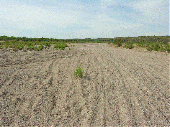
The San Pedro is not free-flowing at the 7B Ranch. The 3072 acre ranch consists of seven miles of bone dry San Pedro riverbed devoid of surface water. It is bereft of the San Pedro’s famously lush willow, cottonwood, ash, sycamore or walnut riparian groves! Any photos with water were taken during the two months of summer thunder storms. The west bank is ecologically sterile, consisting of the dying mining town of Mammoth and huge piles of tailings from the defunct copper mine. However, the dry bed does serve as a roadway for off-road vehicles.
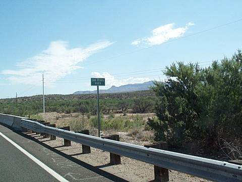
The dry San Pedro at 7B Ranch & Highway 77 crossing—looking south
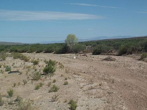
The lone cottonwood illustrates the lack of any typical riparian system—looking north from Highway 77
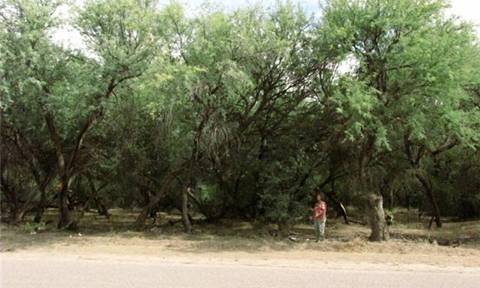
The 7 B ranch is no gift to the beleaguered San Pedro riparian ecosystem, despite its 800-acre, same-aged, monoculture of upland mesquite on its east bank. Only birds found in mesquite all over southern Arizona live here.
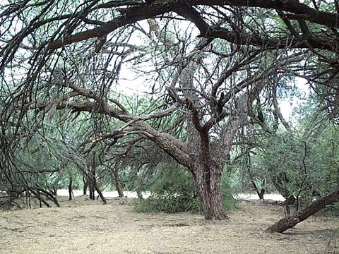
This is certainly no “old-growth” forest. This tree was the largest we could find with a 1 ½ foot diameter trunk. Trees may grow up to 4 feet (1.2 meters) in trunk diameter and live for several hundred years. As illustrated by the dead branches on this tree, since mesquites grow so prolifically, the older trees are crowded out from the thick shade. Most of the trees are less than 1 ft. diameter trunks, typical of the change from ranching to allowing the mesquites to take over during the past 50 years under BHP ownership.
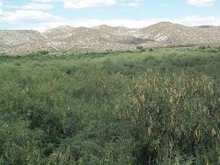
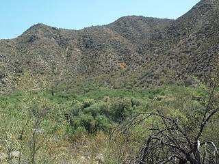
Mesquite Bosques are prevalent along Highway 77
(B) the approximately 160 acres of land located in Gila and Pinal Counties, Arizona, depicted on the map entitled `Southeast Arizona Land Exchange and Conservation Act of 2009-Non-Federal Parcel-Dripping Springs' and dated January 2009; and
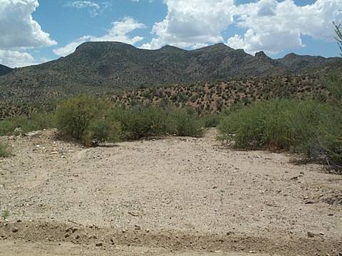
Dripping Springs is a dry wash that until 1970 was called Dumping Springs
There is no info available on this parcel. There is no dripping and no springs going on here. Dripping Springs is a 10 mile or so dry wash. Because of the lack of information in the Bill, it was not possible to ascertain which stretch of the dry wash was designated for public use. In any event, the area is studded with privately-owned small ranches. The Department of Interior stated in a previous Senate hearing that they do not have resources to manage the land, and that they would turn it over to the State of Arizona for a state park and campground. However, at this time Arizona has plans to close eight State Parks due to budget considerations. The time to travel here from Phoenix would be doubled—or more if the wash-board dirt road remains.
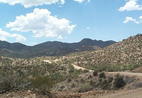
No one has volunteered to pay for a road to the site to replace the curving, wash-board dirt hilly road.
(C) the approximately 956 acres of land located in Santa Cruz County, Arizona, depicted on the map entitled `Southeast Arizona Land Exchange and Conservation Act of 2009-Non-Federal Parcel- Appleton Ranch' and dated January 2009.
The Appleton Ranch is a well-managed ranch with extensive grasslands. The only question: Is it isolated from other Bureau of Land Management lands, so that it will be difficult for them to continue its management.
5) Method of calculation of royalty to public needs to be clarified
In the hearing on June 17, 2009, a royalty was mentioned several times. The references to a royalty in the bill are sketchy and frankly not logical. There is no delineation of actual rate of any royalty, to whom it will be paid, or the timing of the payment.
6) Destruction of Scenic Highway needs to be addressed

Source:
Arizona Department of Transportation
Transportation Enhancement and Scenic Roads
Intermodal Transportation Division
602.712.7774
www.azdot.gov/highways/SWProjMgmt/enhancement/scenic_roads/scenic_arizona.asp