To: Tonto Forest Service
Submitted by: Nancy Freeman,
Groundwater Awareness League,
Executive Director
Contact: E-mail: nancy.freeman@cox.net
Date: April 30, 2009
Re: Comments on Resolution Copper’s draft pre-feasibility plan
Mining destroys landscape and habitat and dreams. There are some places too special to destroy for the sake of dollars. Because of the rise in copper prices in 2002 to 2007, existing mines have exploded their operations—throughout the world, including Arizona. Therefore, the need for new mining operations does not exist. The actual supply and demand ratio for copper is never calculated. As the copper price rises and falls, the “hire today, lay-off tomorrow” cycle creates and destroys dreams of mining laborers.
The Environmental Assessment for Resolution Copper Mining pre-feasibility activities at Superior, Arizona does not adequately address the Apache Leap Tuff hydrology. There is reason for concern for the effects of dewatering the Apache Leap Tuff in the region proposed for mining by the Resolution Copper Company of England* and Australia.** The Environmental Assessment only mentions a couple wells in Apache Leap Tuff, but does not delineate the importance of the assessment of the potential consequences of dewatering of the Apache Leap Tuff, which would include, but not be limited to, the loss of water supply to trees in Oak Flat and dewatering of Devil’s Canyon and its unique vegetation that grows in the cracks and riffs along the canyon’s cliffs.
If there is to be pre-feasibility activities on Forest Service lands, particularly protected Forest Lands, the reason for these activities should reasonable and should be made clear. When the mining company wrote their Environmental Assessment, they gave no such gave no logic or justification at all for disturbing the land. The prolonged drought in Arizona has already put some of the trees in Oak Flat in jeopardy. Further disturbance, for no reason other than “we want to assess” is not an option.
The key issue remains why does the mining company want to obtain current Forest Service land that contains Oak Flat and Devil’s Canyon? They have stated that they cannot mine on their presently owned private land without obtaining this additional Forest Service land. Further, they state that they do not intend to disturb this land. So why is obtaining and assessing the land necessary to their planned mining operations?
The important issue of the dewatering of the Apache Tuft was not listed as a concern in the Environmental Assessment. At present, water, which sustains Oak Flat, the surrounding oak forests, and the unique Devil’s Canyon flora, is protected by Federal Law. The Doctrine of the Federal right to water in public lands was established in 1908 by Winters v. United States.
www.blm.gov/nstc/WaterLaws/pdf/FedResWaterRights.pdf
A case in 1999 in Arizona Supreme Court reasserted the Federal right to water in public lands is still in tact. The presiding judge wrote, “The [Winters’] doctrine applies not only to Indian reservations, but to other federal enclaves, such as national parks, forests, monuments, military bases, and wildlife preserves.”
www.g-a-l.info/AZAdjudication.htm
An understanding of the groundwater hydrology in the entire region is fundamental to comprehending the effects that dewatering the tuff by mining operations will have in the region. The tuff overlays the entire area proposed to be mined and extends up to Top of the World. The tuff is actually a steep escarpment of volcanic ash flow. The ash flow tuff, named after the Apache Leap cliffs, at one time covered approximately 1000 km 2 in the Superior region. Today the tuff has been reduced by extensive faulting and erosion to approximately 250 km 2 and reaches a maximum thickness of some 600 meters.
The proof of the porosity of the tuff, therefore its ability to contain liquids/rain that sustain the oak trees and the other plant material, including the flora on the walls of Devil’s Canyon, is the fact that the Department of Energy contracted with the University of Arizona to test its porosity as a model for the feasibility of storing radioactive waste in volcanic tuffs, particularly the extensive Yucca Mountain Tuff. Obviously, if the tuffs were not porous, they would not be targeted as a storage facility. Excerpt from the report (1):
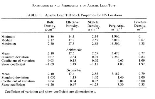
The tuff at the field site has a matrix porosity of approximately 17.5% and contains numerous near-vertical fractures at an average spacing of 1.3 m. More than 270 m of 6.4-cm-diameter oriented core were collected from boreholes drilled to a maximum depth below the surface of 30 m and at a vertical angle of 45°.
Apache Leap Tuff is classified as an ash flow tuff. The cohesion of molten glassy shards and pumice fragments results in significant vertical variations in the physical properties within individual flows. Porosity and permeability of these conglomerates can vary from 70 percent in non-welded zones to less than 5 percent in welded zones.
These significant vertical variations are important in the mining operations at the proposed Resolution Copper mining site. The old pumping records of Magma mine will verify that after rain events the shafts had to be pumped to dewater them. The large amount of water that had collected in Shaft Nine also indicates that the surface water does infiltrate through the tuff in paths that are irregular and unpredictable.
Hammer and Peterson (1968) (2) noted two primary sets of faults in the Superior region. The first and oldest set trends principally to the east and is mineralized. The younger, second set trends generally north to the northwest. Overall, these faults are less mineralized, more dominant and offset the first set of faults and older rocks .
The extensive hydrological research done on the Apache Leap tuff has been funded by the U.S. Department of Energy in an effort to determine if tuff-type material was suitable for storage of radioactive waste. Proposals to use thick unsaturated zones of ash flow tuff such as Yucca Mountain in the Nevada Test Site of the southern Great Basin for high level prompted the studies and funds from the Federal Government. The studies were to identify mineralogical changes and measuring isotopic variations to establish the history of climatic and geo-morphological processes that might affect the isolation properties of a waste repository site, and to obtain information on flow patterns in unsaturated and saturated fractured rock of low permeability.
The major hydrological work was done in 1988 : Stable Isotopes of Authigenic Minerals in Variably-Saturated Fractured Tuff (3)
http://www.osti.gov/bridge/servlets/purl/60500-ybLaTR/webviewable/60500.pdf
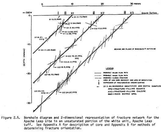
The information was targeted for mineralogical and isotopic analysis included: distinction of flow paths, mixing, and variability; paleoclimatic information; and natural water-rock interactions. Following is a graph of the fracture zones in the region of study.
A brief description of the hydrogeology of the Superior area is given on pages 17-23 of this report. The discussion includes a narrative about the rates of pumping from the Magma shaft #9 - 450 gpm with peaks up to 1200 gpm, and other wells that might influence groundwater distribution in the area, and briefly describes several springs in the region and concludes with a comment about pre-Magma water levels in the area.
The report states that additional research should be able to identify more recent discussions of the regional hydrogeology and more fully document the impact of past dewatering from the shaft and other boreholes on groundwater, springs and surface water in the area of concern. The report further states that the Magma shaft dewatering and the other boreholes in the area appear to have radically changed the groundwater system in the Apache Leap Tuff.
In other words, the current reports on the region are plentiful. There is no justification for any further disturbance, which is sure to create more rifts and fractures in the tuff.
In fact, there is no mention of the environmental hazards of heavy drilling equipment on the tuff. The University of Arizona has also conducted a study (4) to determine the strength criterion that would best represent the failure of the tuff.

Thank you for your attention to these important matters.
Footnotes:
*Rio Tinto: www.riotinto.com/contactus.asp
**BHP: www.bhpbilliton.com/bb/aboutUs/contactUs.jsp
References:
(1) T. C. Rasmussen, D. D. Evens, P. J. Sheets and J. H. Blanford, 1993, Permeability of Apache Leap Tuff: Borehole and Core Measurements using water and Air, Department, Department of Hydrology and Water Resources, University of Arizona, Tucson www.hydrology.uga.edu/rasmussen/pubs/WRR1993b.pdf
(2) Hammer, D.F., and Peterson, D.W., 1968, Geology of the Magma Mine area, Arizona from: 3.0. Ridge (ed.), Ore deposits of the U.S., A.I.M.E. Graton-Sales Volume, pp. 1283-1310
(3) D. S. Weber, D. D. Evans, 1988, Stable Isotopes of Authigenic Minerals in Variably-Saturated Fractured Tuff, Department of Hydrology and Water Resources University of Arizona, Tucson.
www.osti.gov/bridge/servlets/purl/60500-ybLaTR/webviewable/60500.pdf
(4) K. Fuenkajorn, J. J. K. Daemen, 1991, Mechanical Characterization of Densely Welded Apache Leap Tuff, Department of Mining and Geology Engineering, University of Arizona, Tucson
www.osti.gov/bridge/servlets/purl/138134-h8cOro/webviewable/138134.pdf